...is a combination of all my marker file generators. It allows the showing of the following Earthquakes, Volcanos, Storms, Satellites, Eclipses, Update Label, Other Things These Links take you to the config section for the part of the program, How to run the program. Additions that TotalMarker has over the stand alone apart form size can be found here.
Installing
The Program uses a ini file that is created when it is first run. Also on the first run the program creates a database that is used for eclipse data. This is so that very time its run it doesn't have to go and get this large ammount of data.
So just put TotalMarker in your Xplanet directory and run it. It will then write the files that it requires.
The ini file is the thing that holds all the infomation. The file defaults to what is below.
QuakeDetailColorMin=Green This is a quick way to tell how damaging the quake is, the text changes between the colours depending on the magnitude of the earthquake. Other options are any colour listed in RGB.txt
QuakeDetailColorInt=Yellow See QuakeDetailColorMin. Other options are any colour listed in RGB.txt
QuakeDetailColorMax=Red See QuakeDetailColorMin. Other options are any colour listed in RGB.txt
QuakeDetailAlign=Above Where the text is written in relation to the position of the earthquake. Above,Below,Left,Right,Center
QuakeCircleColor=Multi Any Colour listed in RGB.txt or Multi which changes the colour on the magnitude
QuakePixelMax= See QuakePixelMin. Any number
QuakePixelMin= Any number as long as it is smaller than Max number. This is really here so that fixed circles can be produced if you want to do that. Just put the same value in for both min and max
QuakePixelFactor=1 This is a magnitification factor so it will accept any number ie 0.9 will desrease the size of the circle 1.1 will increase it. 1 doesn't change it.
QuakeImageList= An image file that is supported.
QuakeImageTransparent= Any colour in {X,Y,Z} notiation
QuakeDetailList=<mag>You can use anything here. Keywords are:<time>,<date>,<mag>,<location>,<quality>,<lat>,<long> and <depth> eg. Quake happened @ <time> <location> and was a magnitude <mag>.
QuakeDetailColor=Multi Sets the Text colour, Accepts anycolour listed in RGB or Multi, where it uses the top three items.
VolcanoCircleSizeInner=4 This is the size of the inner circle for a volcano size is in pixels
VolcanoCircleSizeMiddle=8 This is the size in pixels of the middle circle
VolcanoCircleSizeOuter=12 This is the pixel size of the largest circle
VolcanoCircleColorInner=Yellow This is the colour of the inner circle, it will accept any color in RGB.txt
VolcanoCircleColorMiddle=Red This is the colour if the middle circle, it will accept any color in RGB.txt
VolcanoCircleColorOuter=Brown This is the colour of the outer circle, it will accept any color in RGB.txt
VolcanoNameOnOff=On By default the name of the volcano will be listed, the other value is Off
VolcanoNameColor=Brown The colour of the text the name is written in
VolcanoNameAlign=Below Where the name is wrtten in relation to the volcano. It will accept Above,Below,Right, Left and Center
VolcanoImageList= If you want to use an image list it here
VolcanoImageTransparent= Any colour in {X,Y,Z} notiation
VolcanoDetailList= Any text you want to appear, Key words are <lat>,<long>,<name>,<elev>, so you could say <name> has started eurpting at <elev>m.
VolcanoDetailAlign=Where the detail is written in relation to the volcano. It will accept Above,Below,Right, Left and Center
VolcanoDetailColor= The text colour for the detail, it will accept nay colour listed in RGB.txt
StormColorTrackReal=Blue The colour of the track that the storm has been along, it accepts any colour listed in RGB.txt
StormColorTrackPrediction=SkyBlue The colour of the track its excepted along, it accepts any colour listed in RGB.txt
StormNameOnOff=On The name of the storm, the other value is Off
StormColorName=SkyBlue The colour of the text that the name is written in, it accepts the colours listed in RGB.txt
StormAlignName=Above The postion of the text in relation to the storm position, it accepts Above,Below,Left,Right,Center
StormDetailList=<type> The text you want to appear by the storm. keywords are <type>,<lat>,<long>,<name>,<speed>. eg Storm <name> is <type>.
StormColorDetail=SkyBlue The text colour of the detail. it will accept the the colours listed in RGB.txt
StormAlignDetail=Below The position of the detail in relation to the storm position
StormImageList= If you want to use an image put it here
StormImageTransparent= Any colour in {X,Y,Z} notiation
StormTrackOnOff=On The track part of the storm other value is Off
NoradIssImage=iss.png This uses the image surplied with xplanet
NoradIssText= If you want a label with the orbit put it here
NoradIssDetail=transparent={0,0,0} trail={orbit,-5,0,5} color=yellow altcirc=0 trail={orbit,-10,0,5} This is any of the options like trails put them here
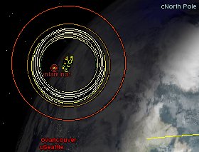
NoradIssOnOff=On Show the International Space Station, On or Off
NoradHstImage=hst.png This needs an image downloaded for it.
NoradHstText= If you want a label with the orbit put it here
NoradHstDetail=transparent={0,0,0} This is any of the options like trails put them here
NoradHstOnOff=On Show the Hubble Space Telescope, On or Off
NoradStsImage=sts.png This uses the image surplied with xplanet
NoradStsText= If you want a label with the orbit put it here
NoradStsDetail=transparent={0,0,0} This is any of the options like trails put them here
NoradStsOnOff=On Show the Space Shuttle, On or Off
NoradSatImage=sat.png This needs an image downloaded for it.
NoradSatText= If you want a label with the orbit put it here
NoradSatDetail=transparent={0,0,0} This is any of the options like trails put them here
NoradSatOnOff=On Show the satellite the Shuttle is meeting, On or Off
NoradMiscOnOff=Off Show other space craft, On or Off
NoradTleNumbers= List the numbers (upto 5) with a space between them, to get them shown. eg 12345 23456 34567. The numbers can be looked up from tm.tle after TotalMarker -norad has been run. Any images must have the same name as the TLE number and be gif files. If there is a demand for this to be removed then I will change it.
NoradMiscDetail= The Detail that can be added for the TLE's listed above.
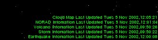
LabelOnOff=On Turn UpdateLabel On or Off
LabelWarningQuake=84600 The number of seconds since last update before the Label changes the colour of the earthquake label. Default is 3 hours
LabelWarningVolcano=604800 The number of seconds since last update before the Label changes the colour of the volcano label. Default is 1 week
LabelWarningStorm=86400 The number of seconds since last update before the Label changes the colour of the storm label. Default is 3 hours
LabelWarningNorad=604800 The number of seconds since last update before the Label changes the colour of the Norad label. Default is 1 week
LabelWarningCloud=21600 The number of seconds since last update before the Label changes the colour of the cloud label. Default is 6 hours
LabelColorOk=Green The colour when the data is up to date
LabelColorWarn=Yellow The colour when the data has failed to update
LabelColorError=Red The colour when the data is out of date.
EclipseOnOff=On If you don't want to have eclipses on your xplanet turn it Off
EclipseNotifyOnOff=On This is used to give 36 hours notice to an eclipse. Again if you don't want it turn it Off
EasterEggSurprises=On This has to be added to the ini file and switched to Off, to remove the surprise. This is here just so that you can turn it off. All the easter egg does is add to a marker file once a year.
Assuming that you aren't afraid of the ini file, I will say that the default will suit most people.
|
Total Marker Version
|
Size
|
OS
|
Windows 1.3.1
|
1.24 MB
|
Download
|
Unix 1.3.1
|
1.16 MB
|
Download
|
I have compiled the unix binaries for Linux, if you are having problems I will compile for other versions of Unix, just email me with the distribution of your choice.
How to Use the Program
The program is run using switches ie TotalMarker -norad will update the norad infomation. I have done it like this becasue while you could update all the infomation at one time, it would be piontless. The Volcano infomation only updates on a Wednesday so cheaking it every 20 minutes along with the earthquakes, just stops a speedy responce for everyone else.
|
Total Marker Switches
|
What needs adding to the command line
|
Recogmended Update Interval
|
-norad
|
-satfile tm
|
Once a day should be fine
|
-storm
|
-markerfile storm -greatarcfile storm
|
Every 3 Hours
|
-cloud
|
Used with UpdateLabel
|
Every 6 Hours when you update the cloud image.
|
-volcano
|
-markerfile volcano
|
Once a week on a Wednesday
|
-quake
|
-markerfile quake
|
Every 20 minutes
|
Eclipse is set from ini file
|
-markerfile eclipse -greatarcfile eclipse
|
Runs when ever any of the others are run.
|
UpdateLabel is set form the ini file
|
-markerfile updatelabel
|
Runs when ever any of the others are run
|
So its just a case of adding the switch(s) to the xplanet command line and then setting Totalmarker to run from a scheduled job. Then forget about it. :)
Improvements in 1.3.1
the main changes between the stand alones and TotalMarker are:-
Norad - if it can't find the right image it will default to the default images, if it can't find them it will download it, if it can.
Eclipse - I think I have fixed the GMT/Local Issue.